Mount Rainier, avatar of beauty and destruction
Published 10:55 am Wednesday, May 27, 2015
It only took seconds to bring about one of Washington’s largest ecological disaster and the world’s largest recorded landslide.
On May 18, 1980, Mount St. Helens’ summit washed out in an enormous landslide, causing a large explosion that threw volcanic rock, ash and gas into the air.
Magma poured out of the volcano’s depths and was soon joined by avalanches of hot ash, pumice and volcanic gas, forming a pyroclastic flow that spread at speeds up to 80 miles per hour down the mountain.
More dangerous still were the lahars, melted glacier water mixed with mud and rocks. The largest lahar traveled down from the volcano into the Cowlitz River, reaching its largest size 50 miles downstream from where it started, bringing indiscriminate destruction to everything in its way.
An estimated 520 million tons of ash choked the sky, bringing darkness to towns and cities more than 250 miles away from the volcano.
Although the eruption happened 35 years ago last week, Mount St. Helens remains high on the United States Geological Survey’s potential threat list.
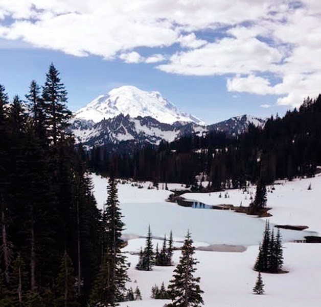
However, eyes have turned to Pierce and South King County’s beautiful backdrop, Mount Rainier, which has taken its place as Washington’s, and even the nation’s, most dangerous volcano.
Mount Rainier and other Cascade volcanoes
“Each of the Cascade volcanoes have a little different personality,” said Carolyn Driedger, hydrologist and outreach coordinator with the United States Geological Survey (USGS). “Mount St. Helens is one of the most explosive volcanoes in the Cascade range.”
In short, Mount St. Helens has the ability to blast magma apart into billions of tiny pieces and make a big ash plume, Driedger said.
Mount St. Helens’ ash plume covered 22,000 square miles of terrain in the U.S., and parts of the plume traveled around the world in just three days, according to the USGS.
“The other volcanoes are not as explosive. Mount Rainier is one of those volcanoes,” Driedger said. “It has less explosions of volcanic ash into the atmosphere and slightly more fluid, gas-rich magma, which means it flows out of the volcano as a lava flow as opposed to being blasted into the atmosphere.”
Less explosions and ash sound like a blessing, but Mount Rainier is deceptively dangerous because of the massive amounts of snow and ice on the volcano.
“We used ice radar on various volcanoes, and we found that Mount Rainier contains as much glacier ice and snow that remains from year to year as all the other Cascade volcanoes combined,” said Driedger. “It’s about an equal amount.”
That means the snow and ice on Mount Rainier is about equal to all the snow on Mount Baker, Glacier Peak, Mount St. Helen, Mount Adams, Mount Hood, Mount Shasta and Mount Jefferson combined.
For the most part, Driedger explained, this is an excellent thing for the people living near the volcano. We use the water as a natural resource and for electricity, and small snow melts help the ecosystem, especially salmon, stay fresh, she said.
But when Mount Rainier erupts, the snow and ice that bring fortune to the valleys below will suddenly bring destruction.
“While Mount Rainier is much less explosive, there is potential for melting of ice and making lahars, these volcanic mud flows that travel down the valleys at great distances from the volcano,” said Driedger.
What is a lahar?
“It’s a slurry of boulders and mud and water and trees and whatever else gets in the way,” Driedger described. “It looks like fresh-flowing concrete.”
While the speed of a lahar is determined by the debris it picks up, the slope of the mountain and how confined it is in a valley, Driedger said, it is not uncommon for lahars to reach 20, 30 or even 40 miles per hour.
According to the USGS, the lahar from the 1980 Mount St. Helens’ eruption damaged or destroyed 27 bridges and nearly 200 homes. It also reduced the channel depth of the Columbia River from 40 feet to 14 feet (stranding 31 ships along the way) and reduced the carrying capacity of the Cowlitz River at flood stage at Castle Rock from 76,000 cubic feet of water per second to less than 15,000 cubic feet of water per second.
A history of lahars
While the USGS describes Mount Rainier currently being at rest between eruptions, there is a recorded history of both game changing eruption-caused lahars and non-eruption-caused lahars in the nearby valleys.
One of the largest lahars happened when the volcano erupted almost six millennia ago.
“5,600 years ago, we had a massive landslide and lahar on Mount Rainier,” said Driedger. “It was something similar that happened on Mount St. Helens, except no lateral blast.”
When the mountain erupted, the White River Valley within what is now known as the Mount Rainier National Park was completely covered by a landslide.
The landslide triggered a lahar, which crashed through Greenwater, the Mud Mountain Dam area and finally into the Enumclaw, Buckley, and even Bonney Lake, according to Driedger.
“The Osceola Mudflow, as we call it, was a game changer for the Enumclaw area. When it reached the mountain front, it spread out and lost its force, and the water separated from the debris,” Driedger said. “The debris was left behind to create the plain that Enumclaw and Buckley and parts of Bonney Lake exist today.”
Driedger explained the land used to be more hilly before the lahar.
“But now, you go out your door or look at your window and it’s as flat as a pancake,” she said. “You’re looking at the surface of the Osceola Mudflow.”
Driedger said this was a serious event for the area, changing not just the topography but water drainage as well. She said the lahar completely rearranged the White River.
Unfortunately, the Osceola Mudflow was not an isolated event.
In the early 1500s, a massive lahar called the Electron Mudflow ripped its way through the Puyallup River Valley, according to Driedger. Unlike the Osceola Mudflow, the Electron Mudflow was most likely not caused by an eruption, Driedger said.
“There were multiple lahars from that time period,” Driedger said. “Some of the sands from those lahars went down to the port of Seattle.”
The lahar didn’t reach the Sound, but Driedger said that sediment is a lasting legacy.
“Sediment continues to move downstream, and can move downstream for decades, centuries, millennia,” she said. “What we are seeing in the Port of Seattle, the sands, it’s runoff from what happened a long time after those lahars happened.”
Present danger
While there is no time table for volcanic activity around Mount Rainier, Driedger said the USGS has been working to predict when a lahar could happen and which direction it would take.
Simply put, their best guess is west.
“Mount Rainier has an additional issue that it has been subjected to many reheatings through time,” Driedger said. “These reheatings means a lot of hot water mixed with sulfur gases in relatively acidic ground water in Mount Rainier. That hot acidic ground water cooks the rocks in some areas, not the entire volcano, but in an east-west trending fracture zone.”
Driedger explained when the rocks are cooked over years and years, they become less stable and eventually transform into clay.
“It’s not a solid rock. Not a stable rock,” she said. “So there are some areas of the volcano that are weakened.”
Until the Osceola Mudflow, the USGS predicted this weakened rock structure stretched from the east side of the volcano to the west. However, the Osceola Mudflow took with it all the weakened clay rock from the east side when the lahar went down the volcano, effectively making the east side more stable.
“We do not expect another Osceola-sized mudflow in any way to come down the White River Valley,” Driedger said.
Even if there was a lahar to come down through the White River Valley, Driedger said, the Mud Mountain Dam will help protect Enumclaw and Buckley in part or in full. Although one of the original purposes of the dam was flood retention, it will hold back lahar mud and debris just as securely, she said.
While the East side of the volcano seems secure, the West side still holds many risks.
The clay-rock mixture that was removed on the East side of the volcano remains on the West side, right above the Puyallup and Carbon River Valleys.
Fortunately for Carbonado, Mount Rainier has little to no history of lahars coming down the Carbon River, said Driedger.
This means that the Puyallup River Valley, and ultimately the city of Orting, lies in the most probable path of a lahar.
“On the west side, not only do we have a lot of hydrothermally altered rock, we also have out greatest population base of any valley that is adjacent to Mount Rainier,” Driedger said. “We have the most people living in the Puyallup River Valley.”
According to Driedger, a large-scale lahar could reach Orting in as fast as 40 minutes.
If you look at the people immediately at risk from an eruption and lahar activity, Driedger said, Mount Rainier is the most dangerous volcano in the state, and even the nation.
Managing the risk
“There is a direct line from Mount St. Helens in 1980… to the preparedness and the awareness we have today,” Driedger said, explaining how the eruption taught scientists they needed to be more involved with the emergency management community when volcanic activity occurs.
“We really had to go out into the emergency management community, talk with emergency managers, helping make preparations and talk to the people who could make themselves more eruption-ready,” she said.
The USGS partnered with Pierce County to install the nation’s first automatic lahar detection system in the nation, according to Tom Sharp, Pierce County Alert and Warning Coordinator at the county’s Emergency Management Department.
Sharp helped install the system in 1998.
“The lahar detection system consists of sensors and equipment to pick up vibration of the movement of material,” Sharp said. “The big reason for the lahar detection system was to detect a non-eruptive lahar – really, an unheralded mudslide.”
Sharp said there are 10 total early detection stations, five in the Puyallup River Valley and five in the Carbon River Valley, where the USGS has predicted the most likely path for a lahar.
According to the USGS, the stations send their data to the Washington State Emergency Operations Center. In the event of a lahar, the center alerts local 24-hour emergency centers, including television and radio stations, but it will also send warnings to schools and hospitals.
“Pierce County has been the most proactive counties, in terms of lahars, in the nation,” Driedger said.
In terms of how individuals should prepare for lahar or eruption, Driedger said residents should remember the acronym LIP: learn, inquire, and plan.
For learning, Driedger said, residents should learn how their daily lives will be disrupted during a lahar. If they don’t know, or want to know more, she said residents should inquire with local public officials what the plan is during an emergency situation. Finally, there’s the planning.
“It’s not just having a first aid kit,” Driedger said. “Have a family emergency safety plan.”
Driedger said it is important for families to know how, where and when to meet up and stick together during an emergency.
Driedger also said it’s important to have a well-stocked emergency kit, which is slightly different from a general kit.
“There will be a little ash with the next eruption of Mount Rainier, so that means having your N95 dust mask,” she said. “Put some of those in your emergency kit. They’re going to fly off the shelves once there is some activity on the mountain, so get them now.”
The USGS also recommends keeping a healthy supply of plastic and tape to seal homes from extreme ash fall and googles to protect eyes from debris.